Tropical Storm Gil was expected to become a hurricane in the eastern Pacific Ocean on Friday but wasn't expected to threaten land, forecasters said.
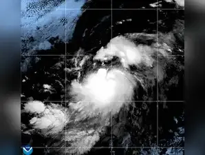
The Miami-based U.S. National Hurricane Center said the storm is about 995 miles (1,605 kilometers) west-southwest of the Baja California peninsula of Mexico.
Gil had maximum sustained winds of 70 mph (110 kph) and was moving west-northwest at 17 mph (28 kph).
There were no coastal watches or warnings in effect. The storm is expected to keep traveling to the west-northwest in the coming days.
Gil was strengthening during a busy period for storms in the eastern Pacific.
Tropical Storm Iona is moving west-northwest in the ocean, about 1,360 miles (2,195 kilometers) west-southwest of Honolulu with maximum sustained winds of 40 mph (65 kph). It was earlier a hurricane but has since weakened. It isn't threatening land.
Iona was expected to cross the International Dateline by late Friday Hawaii Standard Time, forecasters said.
And other storms could develop in the coming days in the eastern Pacific, forecasters said.